RENFREW’S MASTER TRANSPORTATION PLAN: PATHWAYS TO THE FUTURE

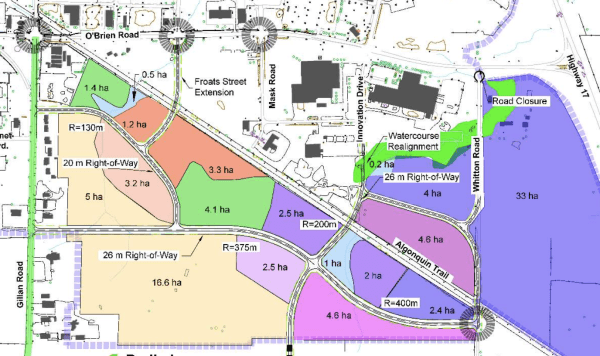
One agenda item for Tuesday evening’s Renfrew Town Council Meeting is the formal introduction of the town’s Master Transportation Plan, a roadmap into the future development of Renfrew’s transportation network as the town grows over the next twenty to thirty years.

Organized around short, medium, and long-term time frames, the plan includes a series of maps/diagrams that display some of the transportation options being looked at. Those maps and diagrams are provided below in the gallery, while the presentation documents are located in full at the bottom of the page.

It’s not my intention here to re-write an already well-written document. BT Engineering, the engineering consultancy group preparing the document, has done a really good job of explaining the underpinning rationale behind their ideas, their scientific methodology, and taking into account the wide array of factors that need to be considered before moving forward with projects that are inextricably linked, as the short term transitions to the medium term, then the medium to the long.

Continue reading “RENFREW’S MASTER TRANSPORTATION PLAN: PATHWAYS TO THE FUTURE”

NEW DEVELOPMENT PLANNED FOR RENFREW EAST

I remember when I was a kid how I’d spend time with pencil and paper and sketch out my development plans for our family home and property should we ever strike it rich by finding oil in the backyard.  I guess it was all part and parcel of being an introvert, and therefore a loner.  And I guess it passed the time on those summer holidays of my youth.

So when Eric Withers, Renfrew’s Director of Development and Environment/Town Planner/Deputy-CAO — a truly acronym defying title — opens his microphone to reveal planning progress involving development of town lands, my interest in a town council meeting literally sky-rockets.  It’s worth the price of the ticket right there.  If they let you in.

Director Withers shared with council plans for the development of an area of town referred to as Renfrew East, a quadrilateral parcel of lands bordered by O’Brien Road to the northwest, Gillan Road to the southwest, the town boundary to the southeast, and Highway 17 to the northeast. So, basically, from a person-on-the-street perspective, go to the Walmart/No Frills corridor along O’Brien Road, and sort of look the other way, across the street, at the lands on the other side.  Or maybe even better, take a walk down the Algonquin Trail, which runs right through the centre of the proposed development.  These two descriptions are not completely adequate or accurate, but it’s enough to give one a general idea.

Continue reading “NEW DEVELOPMENT PLANNED FOR RENFREW EAST”

Blog at WordPress.com.

Up ↑